Learn about Nanki-Kumano Geopark
How the land of Nanki-Kumano has been formed
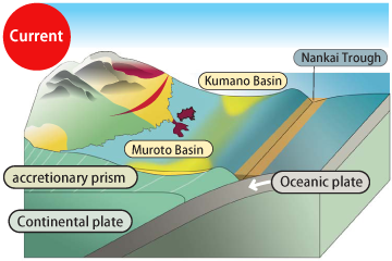
Four Plates and the Japanese Archipelago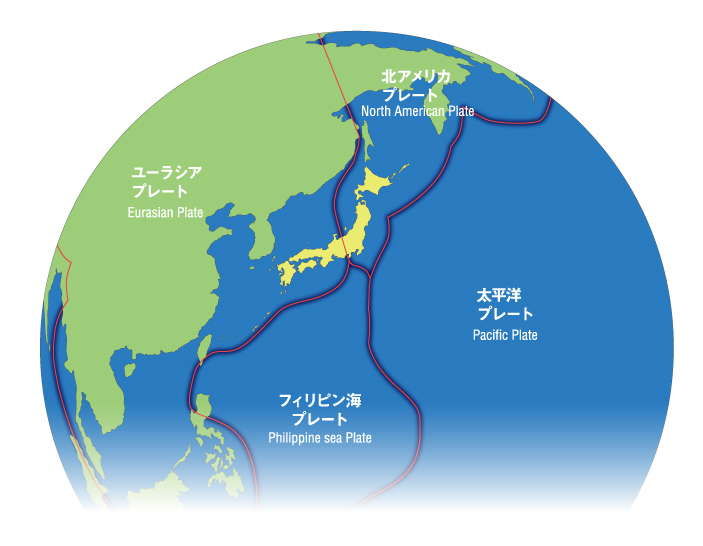
The Earth’s surface is covered by dozens of plates, fitting together like a jigsaw puzzle. Each of these plates moves a few centimeters each year, colliding, separating, and sliding past each other. Japan is situated at a precise point where four dynamic plates meet: two continental plates (the Eurasian Plate and the North American Plate) and two oceanic plates (the Pacific Plate and the Philippine Sea Plate). In Japan, the oceanic plates are subducting beneath the continental plates–that is, the oceanic plates are moving westward toward Japan and sinking under the continental plates.
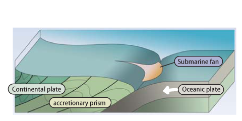
STEP 170 – 20 million years ago: The First Land – The Deep Sea Era
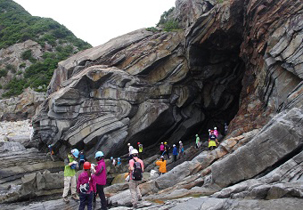
On the ocean floor, oceanic plates were subducting under continental plates. Sediments accumulated on the ocean floor were scraped off and pushed towards the land as the oceanic plates subducted. Eventually, these accumulated sediments attached (accreted) to the land and integrated with it, forming the base of the Nanki-Kumano land known as the “accretionary complex.”
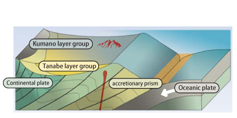
STEP 218 – 15 million years ago: The Second Land – The Shallow Sea Era
The accretionary complex on the seafloor was pushed up to shallower depths, further distorted, and formed a depression known as a sea basin where sediments from the land accumulated. These sediments, termed “forearc basin sediments,” are far younger than the earlier accretionary complex, and form the second type of land in Nanki-Kumano.
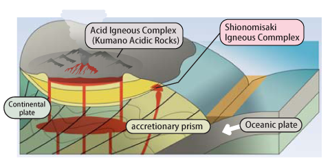
STEP 315 – 14 million years ago: The Third Land – The Era of Intense Volcanic Activity
Subduction caused deep underground rocks to melt into magma. This rose and broke through the overlying strata, including the accretionary complex and forearc basin sediments, erupting onto the surface and forming a large volcano. The land created from this magma is referred to as an “igneous body,” the third landmass in Nanki-Kumano.
STEP 4Present: The Landscape Woven by Three Types of Land
As we have seen, Nanki-Kumano comprises three distinctive types of land, formed and then shaped by subsequent tectonic movements, weathering, and erosion, producing the diverse and fascinating landscape of Nanki-Kumano we see today.
Deepening Our Knowledge
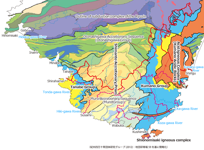
The Nanki-Kumano landscape is composed of three geological bodies formed by plate subduction:
- Accretionary complexes: Strata originally formed on the deep seafloor.
- Forearc basin sediments: Strata formed on shallower seafloors.
- Igneous bodies: Formations that solidified from magma ejected during volcanic activity.
Let’s explore the formation processes of these geological bodies.
STEP 170 – 20 million years ago: Formation of Accretionary Complexes
There are two main types of trench sediment which form accretionary complexes:
- Layers deposited on the ocean floor in the open sea, carried by plate movements all the way to Japan.
- Sediments transported from land to the sea by weathering and erosion and deposited on the seafloor close to the land.
Among these sediments, those that could not subduct under the continental plate with the oceanic plate were scraped off and “accreted” to the landward side, as they were pushed against the continental plate. This formation is therefore referred to as the “accretionary complex.” Over time, new sediments continued to be deposited and accreted, eventually being uplifted above sea level to form new land. This process is still ongoing.
STEP 218 – 15 million years ago: Formation of Forearc Basin Sediments
Like accretionary complexes, forearc basin sediments are layers that were deposited in the sea. Rocks on land, broken down into sand and soil through weathering and erosion, were carried by rivers to the ocean. They settled in a basin on the accretionary complex on the seafloor, creating a distinct layer known as the “forearc basin sediments.” This stratum, deposited at a shallower depth than where the accretionary complex formed, can be considered a “shallow sea strata.” It was eventually uplifted with the accretionary complex, pressed onto the land by plate movements, forming new land in Nanki-Kumano. These sediments are still forming today in forearc basins off the coast.
STEP 315 – 14 million years ago: Formation of Igneous Bodies
The subduction of plates caused deep underground mantle and parts of the deep accretionary complex to melt, forming a magma chamber. Over time, this magma chamber grew and pressure built until fissures appeared on the surface. Magma rose through these cracks and erupted on the surface. This eruption reduced the pressure in the magma chamber, causing the ground above to collapse. Large amounts of magma and pyroclastic materials such as volcanic ash and pumice erupted and filled this caved-in ground, a phenomen called a caldera eruption. Eventually, the erupted magma and pyroclastic materials cooled and solidified, forming a large igneous body.
STEP 4The Landscape Shaped by Three Geological Bodies
These three geological bodies are exposed on the surface due to uplift and erosion of the Kii Peninsula.
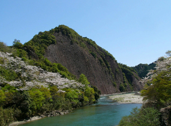
This region, shaped by the subduction of plates, protrudes into the warm Kuroshio Current, creating an area with rugged mountains and seas adjacent to each other.
The humid winds from the Pacific Ocean create a warm and humid climate. Heavy rainfall and swift rivers carve deep valleys, making flat areas rare. However, flat lands such as river terraces have developed in limited areas along rivers.
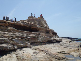
The Kii Peninsula is an example of an uplifted geography. This can be seen in these landforms:
- Wave-cut platforms: Flat rock formations along the coast shaped by continuous wave erosion, resembling giant natural tables.
- Coastal terraces: Elevated areas formed from wave-cut platforms uplifted by repeated major earthquakes, appearing like steps when viewed from the side.
However, there are also examples of “submergent landforms,” where former dry land has sunk below the ocean surface:
- Drowned valleys: Valleys that were once above water but have since submerged, forming dramatic cliffs and scenic views.
- Multi-island seas: Areas where undulating terrain has submerged, showing former mountain peaks as a series of islands.
A survey is currently being conducted in the Kumano-nada Sea off the Kii Peninsula by the IODP (International Ocean Discovery Program) using the deep Earth exploration vessel “Chikyu.” This survey will elucidate the structure of the accretionary complex that is currently forming, and plate movement in the subduction zone. This research is expected to contribute to the clarification of the mechanism of accretionary complex formation in detail and to the understanding of large-scale earthquakes in the plate subduction zone. In addition, mud-diapir structures are being researched on land in the huge forearc basin sediments at Nanki-Kumano. The information gained there will be valuable for underwater methane hydrate exploration.